
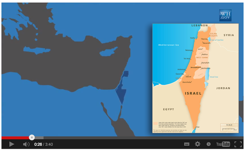
The inset is Israel as it really is, the large map as the WH wishes Israel was
Another example of how the Obama WH cares not one wit about Israel. How crass to publicly demean the only democracy in the Middle East, but then again this is not a new behavior for Obama. It is a continuation of the policy of distancing Israel in order to garner support from our enemies.
From The Washington Free Beacon March 18
Obama’s Middle East Map Erases Israeli Territory
The map of the Middle East displayed in an Obama administration video released days before President Barack Obama’s visit to Israel shows the Jewish state dispossessed of substantial parts of its current territory, including its capital.
The map of Israel, displayed repeatedly during the video, shows the Golan Heights, Jerusalem, northern Israel, and areas surrounding what is currently the West Bank as non-Israeli territory. The Golan Heights is shown as part of Syria; Jerusalem is shown as part of the West Bank; and northern Israel is shown as part of Lebanon.
The itinerary on the White House website also implies that Jerusalem is neither Israel’s capital nor even part of Israel.
The president’s schedule lists two stops in “Tel Aviv, Israel” and one in “Amman, Jordan” but his activities in Israel’s capital city are identified as taking place only in “Jerusalem” — with no country name attached. This keeps with a reluctantly-acknowledged administration policy of denying that Jerusalem is Israel’s capital or even a part of Israel.
No comments:
Post a Comment